Marine Mammal Health Monitoring and Analysis Platform (M.A.P.)
Congressional Authorization of Marine Mammal Health MAP
In December 2022, Congress enacted the James M. Inhofe National Defense Authorization Act, which include the Marine Mammal Research and Response Act (MMRA; pg. 1587). The MMRA instructs NOAA to establish a Marine Mammal Health Monitoring and Analysis Platform (Health MAP) and to make it publicly accessible through a web portal. The Act also requires that additional data collected from stranding or entanglement events, such as weather and tide conditions, morphometrics, histopathology, toxicology, microbiology, virology, parasitology, and life history data, be collected by NOAA, as available from the stranding network members. These additional data will support modeling and analyses that will improve our understanding of the causes of strandings, and help to identify emerging threats.
Need for the Health MAP
 Making marine mammal health information more accessible.
Marine mammals face an increasing number of health threats. Peer-reviewed publications on the increasing frequency of emerging diseases, harmful algal blooms (HABs), and human interactions suggest a decline in marine mammal health. However, a literature review highlighted that these publications are not a reliable indicator of underlying health trends (Simeone et al 2015). The authors called for direct, near-real time access to centralized, standardized marine mammal health data. Beginning in 2014, the Marine Mammal Commission and the National Oceanic and Atmospheric Administration’s (NOAA’s) National Marine Fisheries Service (NMFS) Office of Protected Resources in collaboration with a growing number of partners have been developing a nationally centralized, ultimately near-real-time, system for reporting data on marine mammal health now known as Health MAP.
Vision
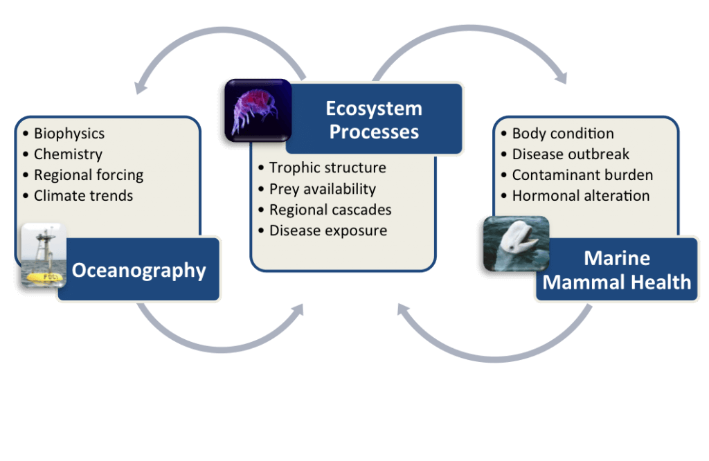
Conceptual diagram of Marine Mammal Health MAP framework showing links and feedbacks among research and observations focused on oceanography, ecosystem processes, and marine mammal health. (Moore and Gulland, 2014)
To highlight and understand the connections between oceanography, ecosystem processes and marine mammal health this project’s mission is to bring together measures of ocean and marine mammal health using a Web-based data management platform. Health MAP will provide online access to marine mammal health data collected through stranding events, and health assessments (among others) that can be visualized and analyzed in relation to environmental conditions such as sea surface temperature, salinity, and primary productivity. This will give the public, scientists, and resource managers an unprecedented ability to detect and communicate potential public and animal health risks in our changing ocean environment and to prioritize management and conservation efforts.
Health MAP will provide:
- A readily accessible, interactive tool to evaluate changes in marine mammal health by location, time and in relation to environmental data.
- Integrated marine mammal health data from a variety of sources including strandings, entanglement response, live capture-release health assessments and other research projects, fisheries bycatch, and subsistence monitoring.
- Marine mammal health data as data layers for integration with ecosystem and oceanographic data through a Web-based data portal such as the U.S. Integrated Ocean Observing System (US IOOS).
Developing Health MAP
Three projects have contributed key pieces over the past five years to the development of a national data management system and portal for Health MAP.
GulfMAP: In the Gulf of Mexico, a prototype database (known as GulfMAP) has been developed for Health MAP data and the first of five nationally planned data diplomats for Health MAP was established in the Gulf to support this project. GulfMAP compiles marine mammal health data collected from stranded cetaceans in the Gulf of Mexico. GulfMAP is being developed in partnership with NMFS, NFWF’s Gulf Environmental Benefit Fund (GEBF), and the Gulf of Mexico Marine Mammal Stranding Network. In 2021, GulfMAP began to transition from an Access-based system to an online system and eventually it will be incorporated into the CETACEAN, Gulf Restoration project.
Data exploration and visualization: This project, led by Axiom Data Science, has developed a user interface, visualization, and analysis tools for Health MAP. Focused initially on data from GulfMAP and interfacing with environmental data from the Gulf Coast Ocean Observing System (GCOOS), several prototype datasets from the Gulf can now be explored, in addition to the original California pilot dataset compiled in 2015. Ultimately the Axiom, or a similar, platform will support all data sources and Health MAP nationally.
System design and architecture: Developers from the Harte Research Institute, Texas A & M University Corpus Christi and GCOOS have also been collaborating with the other projects since October 2016 and have developed system design and architecture recommendations for Health MAP nationally.
Health MAP Partners
In addition to the Commission, partners currently actively engaged in Health MAP development include:
- NOAA Fisheries Marine Mammal Health and Stranding Response Program
- The U.S. Integrated Ocean Observing System
- The Marine Mammal Center
- The National Fish and Wildlife Foundation
- SeaWorld Parks and Entertainment
- Harte Research Institute, Texas A & M University Corpus Christi
- The Gulf Coast Ocean Observing System (GCOOS)
- Axiom Data Science
Other Connected Programs
To make connections between marine wildlife health and terrestrial wildlife health, Health MAP data will be summarized and shared with the Wildlife Health Information Sharing Partnership – event response system (WHISPers). Health MAP data will also be available to the Emergency Response Management Application (ERMA). ERMA provides environmental resource managers with the data necessary to make informed decisions for environmental response, for example to oil spills.
