Marine Mammal Commission

Polar Bear

The U.S. Fish and Wildlife Service (FWS) listed the polar bear as a threatened species throughout its range in 2008 due to the threat of extinction posed by the loss of sea-ice as a result of climate change. Sea-ice constitutes essential polar bear habitat and provides the platform from which polar bears hunt their primary prey, ice seals. In 2016, the U.S. Geological Survey (USGS) updated an analysis of the threats posed to polar bears and concluded that range-wide persistence of polar bears will likely require stabilizing greenhouse gas emissions by the middle of this century.

Female polar bear with cubs

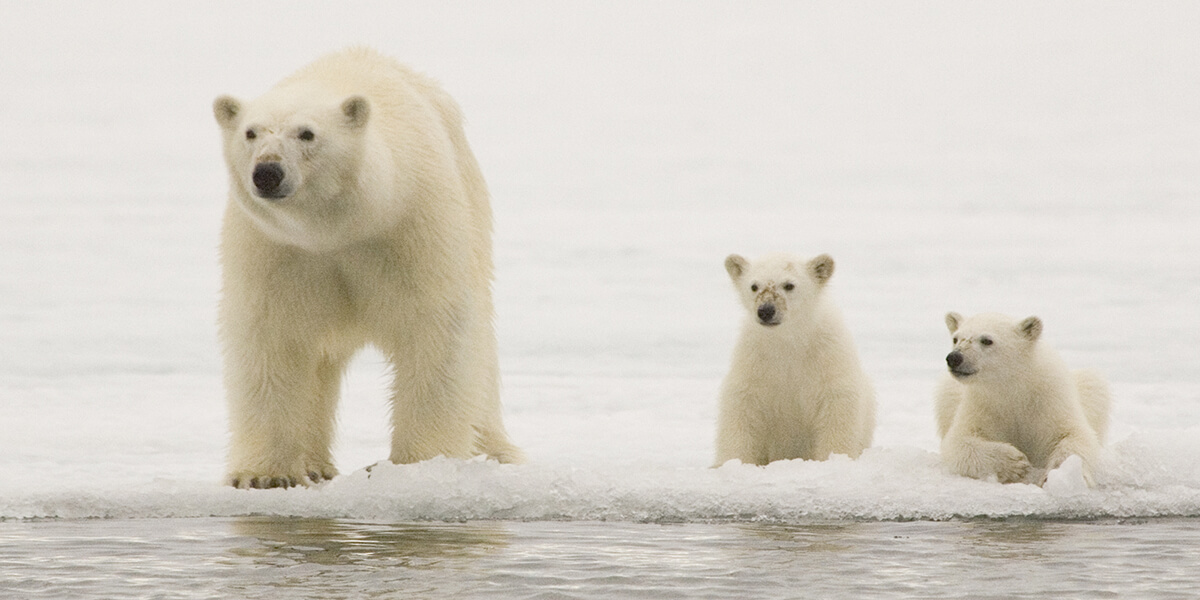
Female polar bear with cubs. (Ian Stirling)

Species Status

Abundance and Trends

Worldwide polar bear numbers are estimated to be around 23,000 animals (Hamilton and Derocher, 2018). Polar bears are distributed among 19 populations, two of which occur in U.S. waters: the Chukchi/Bering Seas population and the Southern Beaufort Sea population. Because polar bear habitat is vast and difficult to access, reliable abundance estimates are difficult to obtain. The best estimates of population size for the two U.S. populations are provided in the stock assessment reports prepared by FWS under the Marine Mammal Protection Act (MMPA). These reports estimate 2,000 bears in the Chukchi/Bering Seas population (based on extrapolated data that were collected in the 1990s) and 900 bears in the Southern Beaufort Sea population (based on a capture-recapture analysis from 2004 to 2010).

The International Polar Bear Specialist Group (PBSG) in early 2015 found data deficiencies for the Chukchi/Bering Seas population, indicating that any abundance estimates and trend assessments are considered unreliable. In 2016, U.S. and Russian researchers conducted aerial surveys using thermal imaging to try to obtain an updated and more reliable population estimate of the Chukchi/Bering Seas polar bear population. This study, published in 2021, estimated the 2016 polar bear abundance in the Chukchi Sea to be between 3,435 and 5,444 bears. A separate study published in 2018 estimated that the average abundance of this population from 2008 to 2015 was approximately 2,900 bears.

A study published in 2020 estimated the abundance of the Southern Beaufort Sea population at 1,300 bears in 2003, a decline to 525 bears in 2006, and then relative stability between 2006 and 2015, with an estimated 573 bears in 2015. These trends and abundance estimates were also supported by a study published in 2021. New modeling methods, that incorporate resource selection, are currently being developed to help reduce the uncertainty associated with polar bear abundance estimates. In addition, a joint effort between the U.S. and Canada is working to produce a new population-wide abundance estimate.

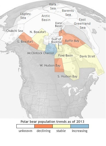
Population trends for the 19 recognized populations of polar bears. (NOAA Climate.gov)

Distribution

Polar bears inhabit the circumpolar Arctic and portions of the subarctic on sea-ice and along coastal areas and islands. Although they sometimes range into international waters, polar bears generally occur in areas under the jurisdiction of five countries: Canada, Greenland (Denmark), Norway, Russia, and the United States (Alaska). Scientists and managers recognize 19 relatively discrete subpopulations, two of which occur in the United States. The Chukchi/Bering Seas population is shared with Russia and the southern Beaufort Sea is shared with Canada.

Cooperative Conservation Efforts

As a party to the 1973 Agreement on the Conservation of Polar Bears, the United States works internationally to pursue the conservation of polar bears and their habitat. The five “Range States” that are parties to the agreement (Canada, Denmark (Greenland), Norway, Russia, and the United States) met in Greenland in September 2015 to discuss a variety of research and management issues. At that meeting, the Range States adopted a circumpolar conservation plan for the species and a two-year implementation schedule. In 2020, the Polar Bear Range States reviewed their progress in achieving their conservation objectives and created a more detailed implementation plan for 2020-2023.

Under a bilateral agreement between the United States and Russia regarding the shared Chukchi/Bering Seas population, the two countries jointly manage this population, including the adoption of annual sustainable harvest limits. At its 2016 meeting the U.S.-Russia Polar Bear Commission agreed to retain the previously adopted annual harvest limit of 58 bears, and in 2018, increased the limit to 85 bears, no more than one-third of which can be female.

In early 2017, the Indigenous People’s Council for Marine Mammals (IPCoMM) convened a meeting of village representatives concerning the establishment of a new Alaska Native organization to engage in co-management of polar bears. Subsequent meetings culminated in the formation of a new organization, the Alaska Nannut Co-Management Council (ANCC), which has been recognized by the FWS as the successor entity to the Alaska Nanuuq Commission under section 501(2) of the MMPA. The council consists of members from 15 tribes that have traditionally harvested polar bears for subsistence. Currently, the ANCC is working with the FWS and local communities to develop a harvest management plan.

What the Commission Is Doing

The Marine Mammal Commission is working closely with the FWS to promote the conservation of polar bears. The Commission participates on U.S. delegations to international polar bear meetings and participated on the polar bear recovery team that developed the Polar Bear Conservation Management Plan. In those capacities, the Commission is integrally involved in advising the FWS and others on conservation needs and priorities for the species and on steps needed to meet U.S. obligations under the two applicable international agreements.

Polar Bear Summit

In coordination with FWS, the Alaskan Nanuuq Commission, Kawerak, and the North Slope Borough, the Commission co-convened a summit on June 1-2, 2016 in Nome, AK, to promote the co-management of polar bears for subsistence use, especially in relation to the agreement with Russia on the conservation and management of the Alaska-Chukotka stock. This meeting allowed federal managers and Alaska Natives to consider options available for implementing U.S. responsibilities under the agreement and provided useful background for the ongoing efforts to form a new Alaska Native organization for polar bears.

Comments on Advance Notice of Proposed Rulemaking

On 9 January 2017, the Commission provided comments to the Fish and Wildlife Service in response to an advance notice of proposed rulemaking seeking input on developing a regulatory program and local management structures to carry out U.S. responsibilities under the United States-Russia Polar Bear Agreement and Title V of the MMPA. The Commission noted that the expectation has always been that U.S. implementation of the agreement would be achieved jointly by the FWS and an Alaska Native partner and that this continues to be the preferred path. The Commission also believed that it should be left largely to the Alaska Native communities to decide how they want to be represented. The Commission supported the adoption of regulations that recognize shared management and enforcement responsibilities and suggested two alternatives for providing the new Alaska Native organization with the necessary legal authority to carry out those functions.

Commission Reports and Publications

For historic information about polar bears and Commission-related activities, see our 2012 annual report.

Commission Letters

Letter Date Letter Description
September 20, 2017

Letter to FWS on the review of draft stock assessment reports for  the Chukchi/Bering Sea and the southern Beaufort Sea stocks of polar bears

January 9, 2017

Letter to FWS commenting on advance notice of proposed rulemaking for meeting U.S. responsibilities under the U.S.-Russia Polar Bear Agreement

July 11, 2016

Letter to FWS on follow-up to the 2016 Nome Polar Bear Summit and on steps needed to identify a new Alaska Native organization for co-management of polar bears

October 16, 2015

Letter to FWS regarding the draft polar bear conservation management plan

February 8, 2013

Letter to FWS regarding an application from the Alaska Oil and Gas Association for authorization to take polar bears incidental to oil and gas exploration activities in the Chukchi Sea

August 3, 2012

Letter to FWS regarding a proposed rule that would re-instate the special rule for polar bears

June 20, 2012

Letter to FWS regarding the listing of polar bear on CITES (the Convention on International Trade in Endangered Species of Wild Fauna and Flora) Appendices

Learn More

Threats

The primary threat to the polar bear is the predicted loss of sea-ice and associated prey base. Other potential threats include oil spills and contaminants, unsustainable removals (e.g., in defense of life or for subsistence), loss of denning habitat, disease, and disturbance from increasing activities in the Arctic. Polar bears are increasingly summering on land in response to sea-ice loss, and models estimate that 80-100 percent of polar bears in the Chukchi Sea and 61-97 percent of bears in the southern Beaufort Sea will spend more than 3 weeks on land by 2065. Recent research efforts by the USGS have assessed how sea-ice loss and altered habitat use affect polar bear home range size, exposure to pathogens and contaminants, body condition, and reproduction.

Current Conservation Efforts

Due primarily to the predicted loss of sea-ice in Arctic waters over the coming decades, the FWS listed the polar bear as a threatened species in 2008. The FWS designated much of the area inhabited by polar bears in Alaska as critical habitat in 2010. That designation, vacated in 2013 by the U.S. District Court in Alaska, was reinstated by a 29 February 2016 ruling of the Ninth Circuit Court of Appeals.

The Endangered Species Act requires that the FWS develop a recovery plan for listed species, including the polar bear. The FWS published its Polar Bear Conservation Management Plan on 20 December 2016 to meet that requirement and to serve as a conservation plan under the MMPA. The plan concluded that range-wide persistence of polar bears will likely require stabilizing greenhouse gas emissions by the middle of this century. Other threats to polar bears were found to be mostly insignificant compared to the risk of extinction posed by climate change and the associated loss of sea ice.

In addition, the five polar bear range states developed a circumpolar action plan for polar bears in 2015, drawing on each country’s national plan. This 10-year plan aims to strengthen range-wide polar bear conservation efforts.

The FWS is currently monitoring subsistence harvest of polar bears, working to expand collaborative population monitoring efforts in the Chukchi Sea and on Wrangel Island in Russia, and is partnering with the North Slope Borough to reduce human-polar bear conflicts.  In October 2021, the FWS requested information that has become available since 2017 for their upcoming 5-year status review under the Endangered Species Act for the polar bear. The Commission plans to follow and provide comments during this process.

The Commission will continue to play an active role in advising the FWS and others on polar bear conservation matters. The Commission also will continue to play an oversight role regarding implementation of U.S. obligations under the applicable international agreements.

Additional Resources

U.S. Fish and Wildlife Service Polar Bear species page

U.S. Geological Survey Polar Bear Research

Polar Bear Specialist Group (PBSG) of the IUCN Species Survival Commission

Inuvialuit – Inupiat Polar Bear Management Agreement

Western North Pacific Gray Whales

A western North Pacific population of gray whales historically migrated along the coasts of Russia, Korea, Japan, and China and was thought to be extinct after being decimated by commercial whaling before the 1970s. Small numbers of gray whales were discovered in the 1990s off Sakhalin Island, Russia, and current conservation efforts focus on mitigating the impacts of rapidly expanding offshore oil and gas development in that region and on reducing the risk of entanglement in fishing gear. Satellite telemetry, photo-identification, and genetic studies are providing new insights on the movements and phenology of gray whales throughout the North Pacific and raising new questions concerning the relationships of the Sakhalin whales to other gray whales in the North Pacific.

Gray Whale shutterstock_100123850

Gray whales are known for their long annual migration between high-latitude summer feeding areas and lower-latitude wintering areas. (Shutterstock)

Species Status

Abundance and Trends

The western North Pacific population of gray whales is listed as an endangered stock under U.S. law and on the Red List of the International Union for Conservation of Nature (IUCN). The population (stock) structure of gray whales (Supplement 22: 166-174) has long been under investigation. There are multiple feeding aggregations and multiple stocks but there is also much uncertainty about stock delineation. In the western North Pacific, a Western Feeding Group feeds off Sakhalin Island and southern Kamchatka. This group may include whales that breed in Asia and others that breed largely with one another while migrating to Mexico in the late autumn. In 2020, based on photo-identification and genetic data, an estimated 220-270 whales (excluding calves) were regularly feeding in the summer and early autumn off Sakhalin, the number having more than doubled since the early 2000s.

Distribution

Photographic and genetic matches, as well as satellite tracking results, have shown that substantial numbers of the Sakhalin whales, after foraging in summer in the western North Pacific, migrate across the southern Bering Sea and Gulf of Alaska to Canada and the U.S. Pacific Northwest, then southward to Mexico for the winter. Those whales then return to Russia in the spring.

The migratory routes and winter habitats of some of the Sakhalin-Kamchatka whales are uncertain. Western North Pacific gray whales historically ranged southward from the Sea of Okhotsk, along the coasts of Korea and Japan to traditional wintering areas in southern China. While there is evidence that some of those that feed off Sakhalin move south to at least Japan in the winter, it is uncertain to what extent the traditional wintering areas in Asia are still used. A photo-identified individual moved back and forth between Sakhalin and the Pacific coast of Honshu, Japan between 2014 and 2016, and a 13-m female died in fishing gear off Baiqingxiang, China, in the Taiwan Strait in November 2011. Recent acoustic evidence from the U.S. Navy has been interpreted as suggesting that some gray whales move through the East China Sea, travelling south in the fall and north in the spring.

A four paneled distribution map of the Western North Pacific Gray Whale during feeding, wintering, and migration.

Western North Pacific gray whale distribution on a seasonal basis (International Whaling Commission, 2016).

Science Provides Clues About Whale Migration

Satellite telemetry, photo-identification, and genetic studies have documented the movements of individual gray whales between feeding areas in the western North Pacific and wintering areas in Baja California, Mexico.

A Russia-U.S. research team satellite-tagged gray whales at Sakhalin Island in 2010 and 2011. In the first successful deployment on October 4, 2010 the investigators tagged a 13-year old male gray whale in the feeding area off Piltun Lagoon along the northeastern Sakhalin coast. The whale, nicknamed “Flex,” remained within 45 km of the tagging site for 68 days and left Sakhalin on December 11. Over the next 55 days, Flex migrated across the Okhotsk Sea, the Bering Sea, and the Gulf of Alaska. The tag stopped sending signals on February 5, 2011 when Flex was 20 km off the central Oregon coast (Mate et al., 2015). Six additional tags were deployed in summer 2011 and at the end of December two, both young females, were still functioning. These two whales moved on separate tracks away from Sakhalin, east across the Okhotsk Sea to the Kamchatka Peninsula, around its southern tip, and then eastward across the Bering Sea toward Alaska. At the end of December 2011, they were still on separate tracks, but both were southeast of the Aleutian Islands in the Gulf of Alaska. While one signal was soon lost, the transmitter on one of these whales, an 8.5-year-old female nicknamed “Varvara,” continued to transmit until the autumn of 2012. After January 1, 2012, the whale continued to travel south from British Columbia, Canada, along the west coast of the United States and Mexico to almost the southern tip of Baja California. At that point, the whale reversed course and returned north past the major nursery lagoons, along the west coast to Alaska, through the Aleutians and back across the Bering Sea. These migratory movements and this whale’s presence in or near the wintering lagoons coincided with the migratory timing of eastern North Pacific gray whales. By mid-May, Varvara had returned to the original tagging area off Sakhalin where her movements were recorded until the tag ceased to function on or about October 14, 2012. The 22,511 km round trip took 172 days and is likely the longest recorded migration of any mammal.

These fascinating tracking results spurred analyses of photo-identification and genetic data which were reported at a meeting of the International Whaling Commission Scientific Committee in 2018. As of 2019, 54 different individual gray whales were known to have visited both Russia and Mexico, confirming that at least 14% of the Sakhalin-Kamchatka whales make the trans-Pacific migration (if not annually at least in some years) and about 0.5% of the whales that have been photo-identified in the Mexican wintering areas are known to be individuals that also visit Russia in summer and fall. In 2021 model results indicated that at least half of the Sakhalin-Kamchatka whales overwinter in the eastern North Pacific. The size of any current western North Pacific wintering population remains highly uncertain.

Genetic matches between two individual gray whales biopsy-sampled off Santa Barbara, California and known from both biopsies and photo-identification at Sakhalin provided further evidence of the connection between the western and eastern Pacific.

Routes of three western gray whales migrating from Sakhalin Island (SI), Russia, to the eastern North Pacific. Cabo St. Lucas (CSL) and Laguna Ojo de Liebre (OdL) are labeled on the map inset of Baja California, Mexico. Image credit: Mate et al., 2015.

Routes of three western gray whales migrating from Sakhalin Island (SI), Russia, to the eastern North Pacific. Cabo St. Lucas (CSL) and Laguna Ojo de Liebre (OdL) are labeled on the map inset of Baja California, Mexico. Image credit: Mate et al., 2015.

What the Commission Is Doing

The Commission has been closely involved in consultations and agency discussions concerning the proposal by the Makah tribe in Washington State for an MMPA waiver allowing resumption of the tribe’s subsistence hunt of gray whales. In particular, it contributed to the determination of conditions attached to the permit to ensure, to the greatest extent possible, that individuals from the western North Pacific that migrate seasonally to coastal North American waters would be fully protected. The Commission was a participating party in the public hearing on this matter, held before an administrative law judge in Seattle in November 2019.

Commission Reports and Publications

For more information on Western North Pacific gray whales, see the Commission’s 2010–2011 annual report and 2012 annual report.

Commission Letters

Letter Date Letter Description

Recommended decision of the Administrative Law Judge on the proposed rule to authorize the taking of gray whales for subsistence and ceremonial purposes by the Makah Tribe.

April 19, 2018

Request for information for the 5-year status reviews of fin and sei whales, and the Western North Pacific gray whale Discrete Population Segment under the Endangered Species Act.

March 13, 2018

Additional consultation under section 103 of the Marine Mammal Protection Act concerning a proposed waiver of the Act’s taking moratorium to authorize the Makah Tribe to hunt gray whales.

July 11, 2017

Consultation under section 103 of the Marine Mammal Protection Act concerning a proposed waiver of the Act’s taking moratorium to authorize the Makah Tribe to hunt gray whales. 

July 31, 2015

Letter to NMFS on the draft Environmental Impact Statement regarding the Makah Tribe’s request to resume hunting gray whales

April 24, 2013

Letter to NMFS regarding a permit application from Yoko Mitani, Ph.D., to conduct research on killer and gray whales in Alaskan waters

Learn More

Threats

The threats to gray whales in the western North Pacific include entanglement and entrapment in fishing gear, ship strikes, noise, and habitat degradation. The whales that migrate to North America for the winter face these same threats in the U.S. and Canada. The intensity of oil and gas exploration, development, production, and transport at Sakhalin Island is of particular concern as a potential threat to the gray whales that depend on that region for foraging in the summer and fall. Two major offshore oil and gas projects are located near the Sakhalin Island feeding area, and additional projects are underway and planned off Sakhalin and in areas near the whales’ migratory routes. The biggest risks from these projects come from underwater noise, including seismic surveys, increased vessel traffic, habitat modification, and the possibility of a major oil spill.

As evidenced by documented deaths in fishing nets in Japan and China as well as observations of entangled animals at Sakhalin, gray whales in Russia, Japan, and China (and Korea if any of the animals still venture into those waters) face the risk of gear entanglement as well as that of vessel strike. An analysis of human-caused scarring on gray whales near Sakhalin Island found that at least 18% of individuals identified between 1994 and 2005 had been entangled at least once.

An unusual mortality event that began in 2019 continues to affect gray whales along the west coast of North America. Elevated numbers of gray whales in poor body condition have been stranding, and it is unknown if western and eastern North Pacific gray whales are equally affected. As of January 2023, over 600 gray whale strandings had been documented since January 1, 2019. The exact cause(s) of the event is (or are) still undetermined.

Current Conservation Efforts

The discovery of gray whales at Sakhalin Island in the 1990s coincided with growing interest in the area for offshore oil and gas development. This raised concern about the potential impacts of such development on the whales. In 2006, IUCN’s Western Gray Whale Advisory Panel (WGWAP) was established to provide independent advice and recommendations on how the operator of one of the largest oil and gas projects at Sakhalin could minimize risks to the whales and their habitat from its activities, particularly seismic surveys, construction, vessel operations, and oil spills. The WGWAP was disbanded in March 2022. The very large body of work by this panel and its predecessors over nearly 18 years are archived at IUCN headquarters in Gland, Switzerland; unfortunately, that organization has not yet restored the availability of these records to researchers and the public, which they were until Russia’s invasion of Ukraine.

Also, for more than 20 years the International Whaling Commission (IWC) and its Scientific Committee have provided an international forum for improving knowledge about western gray whales and the measures needed to conserve them. The IWC’s Scientific Committee completed a range-wide review of population structure and status of gray whales throughout the North Pacific in 2018.

In 2018, NOAA Fisheries announced its intent to conduct a 5-year review for the western North Pacific gray whale to ensure the endangered listing classification is still accurate. The review is still in progress.

Efforts in Alaska and along the U.S. West Coast to reduce entanglement, vessel strike, and disturbance from vessels may also benefit western North Pacific gray whales that migrate to Mexico. Some of those efforts include the creation of marine mammal viewing guidelines in Alaska, the development of innovative fishing gear technologies, the modification of shipping lanes, and the implementation of vessel speed reduction programs.

Additional Resources

Since 2004, IUCN has worked with Sakhalin Energy to provide advice and recommendations on how the company can minimize risks associated with its operations on the Sakhalin gray whales and their habitat. As one part of this broad initiative, IUCN created a panel of independent scientists in 2006 – the Western Gray Whale Advisory Panel (WGWAP) – which provides scientific advice and recommendations on the company’s operational plans and mitigation measures.

Hawaiian Islands False Killer Whale

The false killer whale (Pseudorca crassidens) is a large member of the dolphin family (the delphinids) found in tropical, subtropical and warm temperate waters worldwide. The name reflects a similarity with the shape of killer whale skulls, but the two species are not closely related genetically. The Main Hawaiian Islands (MHI) insular population is a small, discrete population, or stock, that lives exclusively in MHI nearshore waters. The number of false killer whales in this population has declined in recent decades, likely due to interactions with fisheries, to just less than 170 individuals. This population was listed as endangered under the Endangered Species Act (ESA) in 2012.

False killer whales

False killer whales, October 15, 2010. (Robin Baird, Cascadia Research, NMFS Permit # 731-1774)

Species Status

False killer whales are highly social animals that form social clusters, known as ’pods’, of related individuals that travel and forage together with no apparent lasting exchange among these clusters. Within pods, individuals may spread out over many miles when hunting, while smaller sub-groups spread apart and merge over periods of hours to days. The maximum age of false killer whales has been estimated to be over 50 years. While generally considered an open-ocean species, in addition to the insular population around the Main Hawaiian Islands, another insular population is found around the Northwestern Hawaiian Islands. These insular populations overlap with an open-ocean or pelagic population. The MHI insular population consists of four social clusters that occupy waters mostly within about 45 nautical miles of shore, although some individual members have been tracked as far as 71 nautical miles away from the islands. The Hawaiian pelagic population is found up to hundreds of miles from the archipelago, with groups occasionally approaching as close as roughly seven nautical miles of the Main Hawaiian Island. The Northwestern Hawaiian Islands insular population lives within just under 60 nautical miles of the chain’s small islets and banks from Gardner Pinnacles (midway along the chain) to Kauai, with occasional excursions to the west side of Oahu in the MHI. Research indicates that these populations are largely demographically independent and that there is very little genetic interchange among them.

Numerous aerial-survey, photo-identification, satellite-telemetry, and genetic studies have made the MHI insular population the world’s most thoroughly studied false killer whales. Based on photo-identification studies, its current size is estimated to number between 150 and 200 whales (best estimate = 167), which is believed to be significantly fewer than were present in the late 1980s, when aerial surveys around the MHI sighted individual groups of false killer whales in excess of 400 individuals. The major known threat for this and other false killer whale populations in Hawaii is interactions with fisheries that lead to serious injuries or death.

What the Commission Is Doing

The Commission has been an active member of the False Killer Whale Take Reduction Team (FKWTRT) since its inception in 2010. This multi-stakeholder team makes recommendations to NMFS on the development and refinement of the False Killer Whale Take Reduction Plan (FKWTRP).

In 2009, the Commission recommended and supported actions by NMFS to list the MHI insular population of false killer whales as Endangered under the ESA. We also provided support for a study to compile and analyze related biological information. To reduce threats due to fishery interactions to the MHI insular population and other false killer whale populations in Hawaii, we also recommended that NMFS establish a Hawaiian False Killer Whale Take Reduction Team. In February 2010, NMFS established the team and charged it with preparing a plan to minimize false killer whale interactions with the Hawaii longline fisheries for tuna and swordfish. A representative of the Commission has been a member of the team since its inception. In November 2012, the NMFS listed the MHI insular population as Endangered under the ESA.

In 2019, the Commission held its annual meeting in Hawaii, and dedicated one session to understanding the current status of interactions between pelagic false killer whales and the deep-set longline fishery, and between insular false killer whales and State managed hook-and-line fisheries (see session summaries).

In December 2020, the Commission commented on NMFS’s proposed Recovery Implementation Strategy for the insular population. The Commission recommended that the Strategy address the relative urgency of different measures, identify necessary resources and collaborations, and prioritize the monitoring of state commercial and recreational fisheries with the potential to interact with insular false killer whale.

Commission Reports and Publications

See the false killer whale sections in chapters on Species of Special Concern in past Marine Mammal Commission Annual Reports to Congress.

Report prepared for the Marine Mammal Commission:

Baird, Robin W. 2009. A review of false killer whales in Hawaiian waters: biology, status and risk factors.

Commission Letters

Letter Date Letter Description
December 18, 2020

Letter to NMFS regarding its proposed Recovery Implementation Strategy for insular false killer whales

January 2, 2018

Letter to NMFS on a proposed critical habitat designation for MHI Insular false killer whales

July 10, 2014

Letter to NMFS on an incidental harassment permit for Hawaii long line fisheries takes of MHI false killer whales

October 1, 2012

Letter to NMFS on a proposed rule to list MHI Insular false killer whales as endangered

February 17, 2010

Letter to NMFS on the formation and meeting of the False Killer Whale Take Reduction Team

February 4, 2010

Letter to NMFS on actions to establish a take reduction team and take reduction plan for false killer whales in Hawaii

Learn More

Threats

The most significant threat to false killer whales in Hawaii is interactions with fishing gear that lead to serious injury or death. False killer whales are attracted to longline fishing vessels, where they take (depredate) bait and hooked fish, such as mahi-mahi and yellowfin tuna. Consequently, they are sometimes caught on hooks or entangled in fishing lines. Such interactions with Hawaii-based longline fisheries have become a significant conservation issue for false killer whales within Hawaiian waters and on the high seas (in other words, within and beyond the U.S. Exclusive Economic Zone (EEZ) – shore to 200 nautical miles offshore).

Because fisheries operating with the range of the insular populations are not monitored, documented interactions have involved only the pelagic population. From 2003 to 2012, an average of approximately 11 serious injuries and deaths of pelagic false killer whales were estimated to have occurred within the EEZ per year. As early as 2008, when NMFS first recognized three stocks of false killer whales in Hawaii for management purposes, it assessed this rate of serious injuries and deaths as unsustainable by the pelagic stock. In 2010, the National Marine Fisheries Service (NMFS) formed the FKWTRT to address the problem. Within a year, the team  recommended a suite of regulatory and non-regulatory measures, which became the FKWTRP . Following the implementation of the TRP in 2012, the estimated average number of deaths and serious injuries declined inside the EEZ by over half to 5.4 per year for the years 2013-2017. However, since then the bycatch rate inside the EEZ has increased by over three-fold to an average of 17.2 per year from 2018-2022.  Furthermore, deaths and serious injuries continue at high levels outside of the EEZ. From 2002 to 2013, an average just over eight false killer whales were seriously injured or killed outside the EEZ each year. However, in recent years (2014-2022), the bycatch rate outside the EEZ the rate has jumped five-fold to 40.2 per year. Scientists are concerned that these numbers could be even higher due to under-reporting in the U.S. longline fishery, and to the presence of numerous foreign vessels that do not carry fishery observers. From 2018-2021, at least 86 false killer whales have been killed or seriously injured in the deep-set longline fishery operating inside the Hawaii EEZ. These animals most likely belonged to the pelagic stock, but there is a small chance that they could have come from the insular stock. Analyses of interactions data collected since the TRP was implemented in 2012 have indicated that the plan’s mitigation measures have largely failed to work. In late 2018, the team was close to making consensus recommendations to NMFS designed to remedy the failure (see meeting notes), however little progress has been made since. Following a hiatus during the COVID pandemic, the TRT reconvened in 2022 and 2023 to re-examine mitigation options that have the potential to substantially reduce mortalities and serious injuries due to interactions with longline gear.

The increases in mortalities and serious injuries have likely resulted from increases in the size of the fishery and the vulnerability of the whales to interactions with the longline gear. Since 2010, the size of the fishery increased by 20 percent from 122 to 147 permitted vessels in 2022. In addition, over the same period fishermen have increased the number hooks fished per set of the gear by 36 percent from roughly 2,200 to 3,000 hooks per set. In combination, these and other changes have increased the size of the resource available to false killer whales, catch and bait on hooks, by 90 percent. In 2010, the fishery put just over 33 million hooks in the water, but in 2023 that number had grown to over 63 million, The increase has averaged an additional 2.3 million hooks every year. Further, the likelihood that a false killer whale has an interaction with longline gear that results in death or serious injury has increased over the same period. Outside the EEZ, bycatch per unit effort (BPUE) increased from an annual average of 1.5 mortalities and serious injuries per 10 million hooks from 2010 to 2013 to 7.0 from 2014 to 2022. Inside the EEZ, BPUE declined from 3.9 per 10 million hooks in 2010 to zero in 2015, but increased subsequently to an average of 2.9 form 2019-2022.

MHI insular false killer whales are also vulnerable to fishery interactions. Few deaths or serious injuries resulting from fisheries interactions have been documented in this population, but accurate estimates of the number of fisheries interactions are not available because the inshore fisheries are not monitored. However, recent analyses of fishery-related wounds or scars along the mouth-line or on the dorsal fin, documented with photographs, suggest that the frequency of fishery interactions in the insular population occurs at an even higher rate than experienced by the pelagic population, and that the rate may be increasing. To reduce bycatch in the longline fishery of individuals from the MHI insular false killer whale population, the TRP recommended, and in 2012 NMFS implemented, a year-round closure of longline fishing within about 50 nautical miles of the MHI.

Current Conservation Efforts

Hawaiian Pelagic False Killer Whale Population

To reduce bycatch in the Hawaii pelagic population of false killer whales, the TRP includes measures requiring that longline fishermen use ‘weak circle hooks’ and ‘strong branch lines’, as well as certain handling techniques when a false killer whale is hooked. This configuration is designed to enable targeted tuna and swordfish to be caught, but allow the heavier, stronger false killer whales to straighten the hooks and escape. To date, this gear configuration has had mixed success.  A few hooked whales have escaped, but in several cases branch lines broke or were cut. In these cases, hooks were likely to have been left embedded in the whales’ mouths or throats, with up to several meters of monofilament of potentially entangling line trailing from the hooks. Research indicates that odontocetes released with embedded hooks and trailing line are likely to suffer serious injuries that are more likely than not to lead to death. On the 20% of vessel trips that have been observed, compliance with recommended handling techniques has been incomplete (e.g., cutting branch lines instead of applying tension until the hook straightens). Moreover, there is concern that compliance in the un-observed portion of the fleet may be poorer still. The TRT is addressing these issues, looking for ways to encourage the use of stronger branch lines, gathering more information on what happens when a whale is hooked, and improving the release methods used by longline boat crews. In addition, the TRT is considering the use of electronic monitoring to increase the proportion of the fleet that is monitored.

The TRP also includes a contingency measure that would close an area south of the MHI (southern exclusion zone – SEZ) for the remainder of the calendar year if a certain threshold is met for pelagic population bycatch levels within the U.S. For the first time, in 2018, the threshold at the time of two mortalities or serious injuries was met and exceeded when four whales were seriously injured or killed within the EEZ within one year. As a result, the fishery was excluded from the SEZ from July 24th through the end of 2018.

In January 2019, a false killer whale was killed and another seriously injured within the EEZ, again triggering the closure of the SEZ. Because the SEZ was closed two years in row, the area could not be reopened until one or more of the following criteria were met:

  1. There have been no moralities or serious injuries within the EEZ for two years following the second closure;
  2. The number of moralities and serious injures does not exceed the stock’s potential biological removal level (PBR) for two years following the second closure;
  3. The average number of moralities and serious injuries for the most recent five years does not exceed PBR; or
  4. Upon consideration of the TRT’s recommendations and evaluation of all relevant circumstances, the Secretary of Commerce decides that reopening is warranted.

In 2020, NMFS published a new, larger estimate of the size of the pelagic false killer whale stock. The five-year average annual mortality and serious injury rate did not exceed the new PBR, which is based on stock size. Consequently, the third criterion was met, and in August, 2020, NMFS reopened the EEZ. Following a stock-size update in 2020, the trigger to close the SEZ increased from two to four mortalities and serious injuries. In 2021, three mortalities and serious injuries occurred within the EEZ between mid-January and mid-April, and then a fourth interaction occurred in November. However, the determination that the interaction resulted in a serious injury was not made until after the end of the year, and consequently the SEZ was not closed, which made it clear that the closure policy needs to be revised.

In late 2022 and early 2023, the TRT met to recommend new management/mitigation measures that would finally to reduce mortality and serious injury to levels less than PBR.  However, the team could not reach consensus, which left NMFS with the responsibility for amending the TRP using the ideas generated by the team and the recommendations from factions within the team. Proposed mitigation measures included reducing the amount of fishing taking place (effort reductions) and further modifications to the gear and fishing practices. NMFS is expected to publish proposed amendments to the TRP in 2024.

Main Hawaiian Island Insular False Killer Whale Population

After designating the MHI insular population as Endangered in November 2012, NMFS announced its intention to prepare a recovery plan to guide future research and management-recovery activities. In October 2016, NMFS held a meeting to gather information and ideas on actions to include in the recovery plan from false killer whale experts. Participants identified actions needed to monitor and improve information on the population’s status, mitigate threats, and establish measurable recovery criteria. Fishery interactions were identified as the insular population’s greatest threat, but participants also considered actions to assess and mitigate threats associated with contaminants and disease, noise, prey availability, and climate change. Most such actions focused on research to improve information on threats, rather than on mitigation actions, because data on the precise cause and magnitude of potential impacts is quite limited. In October 2020, NMFS released a draft recovery plan and implementation strategy for public review and comment. Commission comments, submitted in December 2020, included recommendations that NMFS: 1) better align the implementation strategy with the recovery plan, 2) focus of those actions that can be practicably implemented immediately, 3) provide details on how resources necessary to implement the recovery plan will be secured, 4) prioritize the monitoring of commercial and recreational fisheries that could be taking insular false killer whales. NMFS published the final recovery and implementation plans in November 2021.

In November 2017, NMFS published a proposal for designating critical habitat. The Commission submitted comments generally supporting the proposal, but noted that it was overly broad. The Commission recommended that NMFS “undertake or support research needed to refine that designation by determining if there are specific areas that are essential to enabling the population to sustain itself in a healthy and productive state, to recover to the point where listing under the ESA is no longer warranted and, ultimately to reach its carrying capacity level.” The proposal identified certain areas used for energy production or military activities to be excluded from the critical habitat designation. The Commission did not fully agree with NMFS’ reasons for excluding some of the areas, and recommended that those areas be included in the critical habitat designation unless NMFS could provide a better justification.

The final Critical Habitat designation, which was announced in July 2018, excluded three additional areas from the designation due to national security concerns, and an assessment that the areas are used only infrequently by false killer whales.

Because interactions documented by observers on longline vessels within the range of the insular population are rare, it is thought that injuries in MHI insular false killer whales are due to commercial and recreational State fisheries that operate closer to shore. Currently there is no mechanism, such as an observer program, for collecting information of false killer whale interactions with State fisheries.

Additional Resources

General Information

NMFS False Killer Whale species page

NMFS 2020 Stock Assessment Reports – False Killer Whale

IUCN Red List – False Killer Whale

Wikipedia – False killer whale

Cascadia Research Collective – False Killer Whales in Hawaii

The Lives of Hawaii’s Dolphins and Whales: Natural History and Conservation. RW Baird. 2016. University of Hawaii Press, Honolulu

False Killer Whale. In: Encyclopedia of Marine Mammals, 3rd Edition. Edited by Bernd Würsig et al. 2018. Elsevier.

Selected Peer-Reviewed Publications

Patterns of depredation in the Hawai’I deep-set longline fishery informed by fishery and false killer whale behavior. Joseph E Fader, RW Baird, AL Bradford, DC Dunn, KA Forney and AJ Read. 2021. Ecosphere

Is it all about the haul? Pelagic false killer whale interactions with longline fisheries in the central North Pacific. David Anderson, RW Baird, AL Bradford, and EM Olsen. 2020. Fisheries Research 230:105665.

Abundance estimates of false killer whales in Hawaiian waters and the broader central Pacific. Amanda L Bradford, EA Becker, EM Oleson, KA Forney, JE Moore, and J Barlow. 2020. NOAA Technical Memorandum NOAA-TM-NMFS-PIFSC-104, 78 p.

Abundance estimates for management of endangered false killer whales in the main Hawaiian Islands. Amanda L. Bradford, RW Baird, SD Mahaffy, AM Gorgone, DJ McSweeney, T Cullins, DL Webster, AN Zerbinia. 2018. Endangered Species Research 36:297-313.

Revised stock boundaries for false killer whales (Pseudorca crassidens) in Hawaiian waters. Amanda L Bradford, EM Oleson, RW Baird, CH Boggs, KA Forney, and NC Young. 2015. NOAA Technical Memorandum NOAA-TM-NMFS-PIFSC-47, 29pp

False killer whales and fisheries interactions in Hawaiian waters: Evidence for sex bias and variation among populations and social groups. Robin W Baird, SD Mahaffy, AM Gorgone, T Cullins, DJ McSweeney, EM Oleson, AL Bradford, J Barlow, and DL Webster. 2015. Marine Mammal Science 31(2): 579-590.

What’s the catch? Patterns of cetacean bycatch and depredation in Hawaii-based pelagic longline fisheries. Karin A Forney, DR Kobayashi, DW Johnston, JA marchetti, and MG Marsik. 2011. Marine Ecology 32(3): 380-391.

Evidence of a Possible Decline since 1989 in False Killer Whales (Pseudorca crassidens) around the Main Hawaiian Islands. Randall R Reeves, S Leatherwood, and RW Baird. 2009. Pacific Science 63(2): 253-261.

False whales (Pseudorca crassidens) around the main Hawaiian Islands: Long-term site fidelity, inter-island movements, and association patterns. Robin W Baird, AM Gorgone, DJ McSweeney, DL Webster, DR Salden, MH Deakos, AD Ligon, GS Schorr, J Barlow, and SD Mahaffy. 2008. Marine Mammal Science 24(3): 591-612

Rice's Whale

In 2021, the Rice’s whale was recognized as a new species, evolutionarily distinct from other Bryde’s whales around the world. Rice’s whale is the only year-round resident baleen whale in the Gulf of Mexico. At an estimated population size of only 51 animals, it is one of the world’s most endangered baleen whales. Rice’s whales are found primarily between 100 and 400 meters water depth. The whales occur primarily in the northeastern Gulf, in what is referred to as the species’ core distribution area, but there has also been a confirmed sighting and regular acoustic detections of Rice’s whales in the western Gulf.

Bryde's/Rice's whale

Rice's whale (formerly Bryde's whale). Photo taken under NOAA research permit #779-1633. (NOAA)

Species Status

First recognized in the Gulf of Mexico in 1965, Rice’s whales were assumed to be a part of the broadly distributed Bryde’s whale complex which occurs in tropical and subtropical waters of the Atlantic, Pacific, and Indian Oceans. After many other large whale species became depleted by commercial whaling, whalers began targeting Bryde’s whales in the 1900’s. Between 1911 and 1987, over 30,000 Bryde’s whales were killed worldwide by commercial whalers.

Genetic analyses recently determined that the Gulf of Mexico population is distinct from other Bryde’s whale populations. Based on genetics analyses and new morphological information, scientists have recognized the Gulf of Mexico Bryde’s whale as a new species, with the name Rice’s whale (Balaenoptera ricei). The common name and species name honors the renowned cetologist Dale W. Rice, who, in 1965, was the first researcher to recognize that Bryde’s whales are present in the Gulf of Mexico. The name ‘Gulf of Mexico whale‘ has also been suggested for this species.

The population size of the Rice’s whale is estimated to number only 51 individuals, and are one of the most critically endangered large whales in the world. They occur primarily in the northeastern Gulf of Mexico, along the shelf break in waters between 100 and 400 meters deep within the De Soto Canyon region off the Florida Panhandle, but visual and acoustic surveys have also confirmed their presence in the western Gulf, recently as far south as Mexico. Spatial density models suggest that suitable habitat is available for Rice’s whales in the entire Gulf of Mexico in the 100 to 400m depth range.

Rice’s whales are threatened by vessel strikes, acoustic disturbance from seismic airguns and other oil and gas-related activities, military training activities, vessel noise, entanglement in commercial fishing and aquaculture gear, marine debris, and pollution from agricultural runoff and oil spills in the Gulf of Mexico.

A petition to list the northern Gulf of Mexico stock of Bryde’s whale (i.e., Rice’s whale) as endangered under the  Endangered Species Act (ESA) was submitted to the National Marine Fisheries Service (NMFS) in 2014. NMFS subsequently initiated a status review of Bryde’s whales under the ESA, which was finalized in December 2016. The status review determined that the Gulf of Mexico Bryde’s whale is taxonomically a subspecies of the Bryde’s whale complex, thus meeting the ESA’s definition of a species. Based on the Gulf of Mexico Bryde’s whale’s small population (likely fewer than 100 individuals), its life history characteristics, its extremely limited distribution, and its vulnerability to existing threats, NMFS determined that the Gulf of Mexico Bryde’s whale was in danger of extinction throughout all of its range. In April 2019, NMFS listed the Gulf of Mexico Bryde’s whale as endangered.

NMFS published a final rule establishing the name change from Bryde’s whale (Gulf of Mexico subspecies) to Rice’s whale under the ESA in August 2021. The immediate next steps are the development of a recovery plan and designation of critical habitat under the ESA. In the interim, NMFS has prepared a guidance document to direct recovery efforts for the Rice’s whale until a recovery plan has been developed.

In the Fall of 2021, NMFS held a series of recovery planning workshops to seek input from experts and stakeholders on (1) approaches for recovery planning that address the challenges relevant to the recovery of the listed species in its current and foreseeable environment; (2) development of possible recovery criteria that would indicate when the species should be considered for delisting; and (3) development of suggested recovery actions to reduce and/or ameliorate the threats to these listed whales. A summary of the recovery planning workshops is now available.

In July 2023, NMFS proposed to designate critical habitat for Rice’s whale in the northern Gulf of Mexico. NMFS identified the following feature as essential to the conservation of Rice’s whale: Gulf of Mexico continental shelf and slope waters  from 100 m to 400 m deep that support individual growth, reproduction, and development, social behavior, and overall population growth. This feature has the following attributes that support Rice’s whales’ ability to forage, develop, communicate, reproduce, rear calves, and migrate:

  • Sufficient density, quality, abundance, and accessibility of small demersal and vertically migrating prey species, including scombriformes, stomiiformes, myctophiformes, and myopsida;
  • Marine water with (i) elevated productivity, (ii) bottom temperatures of 10–19 degrees Celsius, and (iii) levels of pollutants that do not preclude or inhibit any demographic function; and
  • Sufficiently quiet conditions for normal use and occupancy, including intraspecific communication, navigation, and detection of prey, predators, and other threats.

Comments on the proposed critical habitat designation were due to NMFS by October 6, 2023. NMFS is currently reviewing comments before issuing a final critical habitat designation.

What the Commission Is Doing

The Marine Mammal Commission is working with NMFS and other partners in the Gulf of Mexico to expand research and monitoring efforts for all marine mammals.

The Commission recently partnered with the Smithsonian Institution and NMFS to raise awareness regarding Rice’s whales. A special symposium focused on Rice’s Whales and other endangered large whales, “Whales on the Brink“, was convened on November 16, 2023, at the Smithsonian National Museum of Natural History, as part of the 50th Anniversary Celebration of the Endangered Species Act. The symposium followed the Commission’s 2023 Annual Meeting, which was held November 14-15, 2023 at the Navy Memorial Visitor’s Center in Washington, D.C.

The Commission regularly contributes guidance and input to NMFS on its deployment  of acoustic recorders around the Gulf of Mexico, including in Mexican waters, to detect the presence and seasonal distribution of Rice’s whales and other offshore marine mammals and to understand the various sources and sound levels associated with human activities in the Gulf. More about passive acoustic research being conducted by NMFS and its partners in the Gulf of Mexico, including the Long-Term Investigations into Soundscapes, Trends, Ecology, and Noise in the Gulf of Mexico (LISTEN GoMex) project, can be found on the NMFS Southeast Fisheries Science Center’s Passive Acoustic Research webpage.

The Commission submitted comments in July 2023 in support of a petition to establish vessel speed and other vessel-related measures to protect Rice’s whales. However, NMFS denied the petition in October 2023, citing the need to focus on other high priority conservation actions including finalizing critical habitat for the species, conducting additional vessel risk assessments, and developing a recovery plan for the species. The Commission also submitted comments on NMFS’s proposal to designate critical habitat for Rice’s whales. A decision on that action is still pending.

Commission staff recently served on a NMFS Steering Committee to convene experts and stakeholders in a series of workshops to identify recovery criteria and recovery actions for the Rice’s whale, as part of NMFS’s recovery planning efforts. Those workshops were held in October and November of 2021, and a summary of the workshops is now available.

Commission staff also served as one of two technical monitors on a RESTORE Act Science Program-funded project to evaluate Trophic Interactions and Habitat Requirements of Gulf of Mexico Rice’s Whales. The NMFS Southeast Fisheries Science Center, along with its partners from Florida International University and Scripps Institution of Ocenography, conducted the project from 2017 to 2021. The shipboard surveys conducted visual sightings, passive acoustic monitoring, tagging, prey characterization from echosounders and net tows, and the collection of biological samples. The field work focused on habitat characterization in the eastern Gulf of Mexico. Outcomes included an improved understanding of population status, identification of habitat features and characteristics, and a better understanding of the risk of exposure to human activities. A video presentation summarizing research from the RESTORE Science Program is available on the project website, along with additional information about the project.

In April 2015, the Commission held a meeting to identify high priority, overarching data needs and to identify potential funding sources and opportunities for expanding marine mammal research and monitoring in the Gulf. Presentations and a summary of the meeting are available here.


Commission Reports and Publications

Gulf of Mexico Marine Mammal Research and Monitoring Meeting Summary (Marine Mammal Commission 2015)

Assessing the Long-term Effects of the BP Deepwater Horizon Oil Spill on Marine Mammals in the Gulf of Mexico: A Statement of Research Needs (Marine Mammal Commission 2011)

Commission Letters

Letter Date Letter Description
September 28, 2023

Letter to NMFS on its proposed critical habitat for Rice’s whales.

July 21, 2023

Letter to BOEM on its FY2024-25 Environmental Studies Program Studies Development Plan.

July 6, 2023

Letter to NMFS on a petition to establish vessel speed restrictions and other vessel-related measures to protect Rice’s whales.

February 9, 2022

Letter to BOEM on its intent to prepare an environmental assessment on commercial wind leasing in the Gulf of Mexico.

December 16, 2021

Letter to BOEM on its call for information and nominations for commercial wind energy leasing in the Gulf of Mexico.

December 10, 2021

Letter to BOEM on its FY 2023-2024 Environmental Studies Plan, including a recommendation to continue funding ecosystem-wide surveys for marine mammals in the Gulf of Mexico.

May 5, 2021

Letter to Deepwater Horizon Regionwide Trustee Implementation Group on its draft restoration plan for marine mammals and other species in the Gulf of Mexico.

December 9, 2020

Letter to BOEM on its FY 2022-2023 Environmental Studies Plan, including a recommendation to continue funding ecosystem-wide surveys for marine mammals in the Gulf of Mexico.

July 15, 2019

Letter to Deepwater Horizon Open Ocean Trustee Implementation Group on its draft restoration plan 2 for marine mammals and other species in the Gulf of Mexico.

February 4, 2019

Letter to BOEM on its FY 2020-2022 Environmental Studies Plan, including a recommendation to expand passive acoustic monitoring in Gulf of Mexico Bryde’s whale habitat.

October 31, 2018

Letter to NMFS on an exempted fishing permit application for golden crab trap pot gear in the Gulf of Mexico.

August 21, 2018

Letter to NMFS on an application submitted by BOEM seeking issuance of regulations for taking of marine mammals incidental to geophysical surveys in the Gulf of Mexico under section 101(a)(5)(A) of the Marine Mammal Protection Act (MMPA).

February 6, 2017

Letter to NMFS on its proposed rule for listing the Gulf of Mexico Bryde’s Whale as an endangered species under the Endangered Species Act.

December 4, 2015

Letter to Deepwater Horizon Natural Resource Damage Assessment Trustees on its draft damage assessment and restoration plan for the Gulf of Mexico.

September 28, 2015

Letter to the Gulf Coast Ecosystem Restoration Council on its draft Funded Priorities List for Gulf of Mexico restoration activities.

July 9, 2013

Letter to BOEM on its notice of intent to prepare a programmatic environmental impact statement on geological and geophysical activities in the Gulf of Mexico.

July 8, 2013

Letter to the Department of Commerce/Gulf Coast Ecosystem Restoration Council on its initial draft comprehensive restoration plan for the Gulf of Mexico.

December 28, 2012

Letter to NMFSon the Deepwater Horizon Natural Resource Damage Assessment Trustee Council’s development of a restoration plan to address injuries from the oil spill.

Learn More

Threats

The Rice’s whale is threatened by vessel strikes, acoustic disturbance from seismic airguns and other oil and gas-related activities, military activities, entanglement in fishing gear and aquaculture nets, marine debris, vessel noise, oil spills, and pollution.

Rice’s whale sightings and strandings are rare, but on 29 January 2019, a 38-foot male stranded in the Florida Everglades. A necropsy of the whale determined that it was underweight, and an examination of its stomach revealed a piece of hard plastic, approximately 5 cm by 7.5 cm in size. The plastic piece had sliced through part of the whale’s stomach, which likely contributed to its death. That whale’s skeleton is now at the Smithsonian Institution in Washington, D.C., and it represents the holotype for the new species.

Current Conservation Efforts

NMFS scientists are in the process of analyzing data recently collected on the abundance, distribution, diet, behavior, and habitat use of Rice’s whales in the Gulf of Mexico. The data, presented at a series of expert workshops convened in October and November 2021, are helping to identify recovery criteria and recovery actions for the Rice’s whale as part of NMFS’s recovery planning efforts to conserve and protect this stock from natural and human-caused threats. These data will also assist in efforts to designate critical habitat for the species under the ESA, and to help update Rice’s whale Biologically Important Areas.

The Future/Next Steps

Actions will be needed to ensure that energy development, fishing, aquaculture, shipping, and other potentially harmful activities are prevented from expanding into Rice’s whale core habitat areas. NMFS is conducting extensive passive acoustic monitoring throughout the Gulf of Mexico to determine, among other objectives, the extent to which Rice’s whales occur in areas beyond the core habitat identified in the eastern Gulf. Continued visual and acoustic surveys, biological sampling, and trophic studies are needed to understand Rice’s whale foraging and diving behavior, prey preferences and availability, and the potential effects of climate change on this endangered species.

Additional Resources

NMFS Rice’s Whale Species Page

Long-term Investigations into Soundscapes, Trends, Ecology, and Noise in the Gulf of Mexico (LISTEN GoMex)

“Whales on the Brink” Symposium featuring Rice’s Whales, November 16, 2023, at the Smithsonian National Museum of Natural History

Rice’s Whale Recovery Planning (April 2022)

Trophic Interactions and Habitat Requirements of Gulf of Mexico Rice’s Whales (March 2022)

NMFS New Species of Baleen Whale in the Gulf of Mexico (January 2021)

NMFS Discovering a New Species of Whale (video)

NMFS 2022 Stock Assessment Report for Rice’s Whale (May 2023)

NMFS Rice’s Whale Core Distribution Area Map and GIS Data (2019)


Florida Manatee

The Florida manatee, a subspecies of the West Indian manatee, is a large, slow-moving marine mammal with an elongated, round body and paddle-shaped flippers and tail. Manatees are herbivores, feeding solely on seagrass, algae and other vegetation in freshwater and estuarine systems in the southeastern United States. Florida manatees can be found as far west as Texas and as far north as Massachusetts during summer months, but during the winter, manatees congregate in Florida, as they require warm-water habitats to survive. Abundance of the subspecies has increased over the last 30 years, which prompted the U.S. Fish and Wildlife Service (FWS) to downlist the West Indian manatee from endangered to threatened in 2017. However, due to their slow speed and relatively high buoyancy, manatees are often struck by vessels, which is the primary cause of human-related deaths of the species. Additionally, manatees continue to be threatened by loss of warm-water habitat and periodic die-offs from red tides and unusually cold weather events. Florida manatees are managed jointly by both FWS and the Florida Fish and Wildlife Conservation Commission (FWC).

Florida manatees swimming at Three Sisters Spring, Crystal River, Florida.

Florida manatees at Three Sisters Spring, Crystal River, Florida. (Cynthia Taylor, Sea to Shore Alliance)

Species Status

Abundance and Trends

A 2019 synoptic survey documented a minimum population estimate of 5,733 manatees, including 2,394 on the East Coast and 3,339 on the West Coast. Synoptic surveys do not account for animals absent from survey sites or not seen by observers, so they are considered minimum counts. The most recent state-wide abundance estimate is 8,810 manatees. This estimate is based on aerial surveys conducted in 2015-2016 and accounts for possible error in detection of animals using a statistical model developed by FWC’s Fish and Wildlife Research Institute (FWRI). A new abundance estimate based on survey data from 2021 and 2022 is expected by the end of 2024.

Florida manatees have been divided into four regional management units: the Atlantic Coast, Upper St. Johns River, Northwest, and Southwest. Prior to 2020, the Atlantic Coast unit was thought to be stable or slowly increasing. The ongoing unusual mortality event that began in December 2020 is primarily affecting that management unit and the effects on population size and trend are currently unknown. The other three management units all appear to be increasing.

Distribution

The Florida manatee occurs only in coastal and inland waters of the southeastern United States, where it occupies the northern limit of the species’ range. Because prolonged exposure to water temperatures below 18°C (65°F) can be lethal to manatees, Florida manatees are confined largely to the southern two-thirds of the Florida Peninsula in winter. There they aggregate at warm-water springs and thermal outfalls from power plants, or remain along the edge of the Everglades at the southern tip of the state. As water temperatures rise in spring and summer, Florida manatees disperse throughout the state and into neighboring states.


Count of total manatee mortalities starting in 1990, as of September 2022, increasing over time.

Count of total manatee mortalities per year starting in 1990 (as of September 2022).

Unusual Mortality Event: 2021 to present

Beginning in December 2020, a drastic uptick in carcasses and manatees requiring rescue was observed along the Atlantic coast of Florida. The increased number of stranded and dead manatees led FWS to declare an unusual mortality event (UME) in March 2021. Data released by FWC reflect a total of 1,100 manatee mortalities in 2021, nearly twice the number recorded in 2020. Agencies and partners from the Manatee Rescue and Rehabilitation Partnership also helped to rescue over 140 manatees statewide. In 2022, 800 mortalities and 106 manatee rescues were reported, and 518 mortalities and 146 rescues were reported in 2023.

While some of the mortalities have been attributed to traditional causes of manatee deaths, including cold-stress and vessel collisions, the majority of recovered carcasses and rescued animals have been emaciated. Researchers now largely attribute the UME to starvation due to loss of seagrass, a primary food source of manatees, in Indian River Lagoon and other warm-water estuaries. Poor water quality in nearshore waters is believed to be a leading factor in the drastic reduction of seagrass beds.

In December 2021, several environmental organizations announced their intent to sue the Environmental Protection Agency (EPA) for failing to reinitiate consultation with FWS under the section 7 of the Endangered Species Act, specifically regarding inadequate water quality standards set by EPA that now adversely affect manatees. The Commission sent a letter to FWS in December 2021 recommending that FWS increase the capacity of rehabilitation and other facilities to house manatees, approve contingency sites for the temporary holding of manatees, incorporate expert findings into any supplemental feeding program, and continue to work closely with FWC and other members of the Manatee Rescue and Rehabilitation Partnership to obtain funding to increase facility capacity and to respond to and rehabilitate live-stranded manatees.

During the winter months, the impacts of seagrass loss are most severe, as manatees rely on warm-water sites to maintain their body temperature. FWS implemented a pilot supplemental feeding program in the winter of 2021-2022 in Indian River Lagoon to help sustain manatees through the cold months until warmer temperatures allowed animals to disperse and find alternative foraging sites. The supplemental feeding trial continued during the winter of 2022-2023, with over 399,000 pounds of romaine lettuce fed to the manatees at a single site. The supplemental feeding program was discontinued in the 2023/2024 winter season because seagrass monitoring efforts indicated adequate foraging resources.

FWS and FWC, in collaboration with the Manatee Rescue and Rehabilitation Partnership, continue to prioritize responding to and rehabilitating live animals in distress. In the long-term, efforts are underway to restore seagrass beds and natural warm-water habitat for manatees.

Endangered Species Act listing

The Florida manatee is a subspecies of the West Indian manatee, which, until 2017, was listed as endangered under the Endangered Species Act (ESA). However, in 2012, FWS received a petition requesting that all West Indian manatees, including Florida manatees and the second subspecies, Antillean manatees, be reclassified from endangered to threatened under the ESA. In April 2017, FWS officially downlisted the species. In its final rule, the agency cited that the West Indian manatee had met the downlisting criteria established in the 2001 Florida Manatee Recovery Plan and thus warranted reclassification from endangered to threatened.

Given the extreme number of manatee mortalities along the Atlantic coast since December 2020 and the declaration of the UME, there is growing support among Florida legislators for uplisting the species to endangered once again. In November 2022, FWS received a petition requesting that the West Indian manatee be reclassified as endangered. FWS found that the petition presented substantial information and announced their intent to complete a status review in October 2023. FWS plans to issue a 12-month petition finding to address whether reclassification is warranted.

FWS also initiated a five-year status review of the West Indian manatee in July 2021. The purpose of the review is to assess ongoing conservation efforts and ensure that listed species are appropriately classified under the ESA.

More Information

Manatees and Warm-Water Refuges

Manatee Harassment

What the Commission Is Doing

Legal Protection

In response to the 2016 proposed listing change of the West Indian Manatee by FWS, the Commission submitted a letter recommending that the two subspecies, the Florida manatee and the Antillean manatee, be considered separately. The Commission noted that despite an increase in the population size of Florida manatees, the growth of the population over the past 30 years has remained slow while manatee mortalities continue to reach record highs. The Commission also expressed concern with the loss of warm-water habitat due to eventual retirements of power plants over the next 30 to 40 years. This could threaten the future manatee population in Florida and reverse past recovery progress.

In addition, the Commission opposed changing the listing status for Antillean manatees, which, outside of Puerto Rico, continue to face considerable threats from habitat loss and degradation, hunting, fisheries bycatch, pollution, and human disturbance. The Sirenia Specialist Group of the International Union for the Conservation of Nature (IUCN) estimates that only about 2,500 mature Antillean manatees remain and projected that the subspecies would decline by 20 percent over the next two generations (40 years) in the absence of effective responses to current and projected anthropogenic threats.

FWS downlisted the West Indian manatee from endangered to threatened on 5 April 2017. However, the Commission remains committed to engaging with federal, state and local authorities to ensure adequate protections continue for the species and regularly participates in stakeholder meetings hosted by FWC. We continue to support an assessment of the potential harmful impact on manatees of a reduction in warm-water refuges through the retirement of power plants, as well as the effectiveness of boat speed restrictions.

Manatee Harassment

The Commission has also been concerned about the harassment of manatees by swimmers, divers, and kayakers at the Kings Bay warm-water refuge in the town of Crystal River, and particularly at Three Sisters Springs, the site’s largest spring. Parts of Kings Bay, including Three Sisters Spring, are managed as part of the FWS’s Crystal River National Wildlife Refuge. In August 2014, the Save the Manatee Club petitioned the FWS to close Three Sisters to human access during the winter manatee season. In response, the Commission wrote to the FWS in November 2014 noting the urgent need for further steps to reduce harassment in the spring and repeated past recommendations that the FWS adopt a no-touch policy and a minimum approach distance for swimmers.

In early 2015, the Commission conducted a site visit to Crystal River and met with involved federal, state, and local officials as well as local citizens and environmental group representatives to review manatee management efforts and plans at Crystal River. These matters were further considered during the Commission’s 2015 annual meeting. During the winter of 2014-15, Refuge staff temporarily closed Three Sisters Spring to human access on several occasions when high numbers of manatees were present in the spring. In 2017, FWS released an updated management plan for Three Sisters Spring, which includes guidelines to close the spring to public access when water temperatures in the region drop to 17 degrees Celsius.

Commission Reports and Publications

See Florida manatee sections in chapters on Species of Special Concern in past Annual Reports to Congress.

Laist, David W., Taylor, Cynthia, and Reynolds, John E. III. 2013. Winter Habitat Preferences for Florida Manatees and Vulnerability to Cold.

Laist, David W. and Shaw, Cameron. 2006. Preliminary Evidence that Boat Speed Restrictions Reduce Deaths of Florida Manatees.

Laist, David W. and Reynolds, John E. III. 2005. Influence of Power Plants and Other Warm-Water Refuges on Florida Manatees.

Laist, David W. and Reynolds, John E. III. 2005. Florida Manatees, Warm-Water Refuges, and an Uncertain Future.

Lowry, Lloyd, Laist, David W., and Taylor, Elizabeth. 2007. Endangered, Threatened, and Depleted Marine Mammals in U.S. Waters.

Taylor, Cynthia R. 2006. A Survey of Florida Springs to Determine Accessibility to Florida Manatees (Trichechus manatus latirostris): Developing a Sustainable Thermal Network.

Weber, Michael L. and Laist, David W. 2007. The Status of Protection Programs for Endangered, Threatened, and Depleted Marine Mammals in U.S. Waters.

Commission Letters

Letter Date Letter Description
December 13, 2022

Letter to Florida Fish and Wildlife Conservation Commission on the proposed rule to establish a seasonal manatee protection zone at the Florida Power & Light Cape Canaveral Energy Center Interim Warm-water Refuge in Brevard County, Florida.

December 2, 2021

Letter to FWS on immediate actions for responding to the unusual mortality event involving the Florida manatee 

April 8, 2016

Letter to FWS on proposed reclassification of the West Indian manatee from endangered to threatened

November 24, 2015

Letter to FWS on a revised draft environmental assessment with options to protect Florida manatees in the Three Sisters Springs Unit of the Crystal River National Wildlife Refuge

September 28, 2015

Letter to Gulf Coast Ecosystem Restoration Council on a draft Funded Priorities List for Gulf of Mexico restoration activities under the RESTORE Act

September 4, 2015

Letter to FWS on a draft environmental assessment to reduce manatee harassment in the Three Sisters Springs Unit of the Crystal River National Wildlife Refuge

December 30, 2014

Letter to FWS on proposed measures for manatee viewing at the Crystal River National Wildlife Refuge

November 3, 2014

Letter to FWS on a petition to designate Three Sisters Spring as a manatee sanctuary

September 2, 2014

Letter to FWS_on a petition to reclassify West Indian manatees from endangered to threatened

September 21, 2011

Letter to FWS on managing warm-water refuges

August 22, 2011

Letter to FWS on a proposed rule to establish a manatee refuge in Kings Bay, Florida

April 26, 2010

Letter to FWS on reconvening the manatee recovery team and warm water task force

January 14, 2010

Letter to FWC on a draft final endangered and threatened species listing process rule

October 29, 2009

Letter to FWS on a petition to revise critical habitat for Florida manatees under the Endangered Species Act

September 10, 2009

Letter to FWS on draft stock assessment reports for the Florida and Puerto Rico stocks of West Indian manatees

Learn More

Threats

Along the east coast of Florida, loss of seagrass, an important food source for manatees, may pose the greatest threat to the species and is considered the driving factor of the ongoing Unusual Mortality Event (UME). A 95% reduction of seagrass since 2011 has largely been attributed to increasing harmful algal blooms and reduced water quality.

Cold stress poses another threat to manatees and was likely a contributing factor to the increase in manatee mortalities in 2021. As manatees continue to lose warm-water habitat from the destruction of natural springs and the closure of power plants, full recovery of the species becomes more difficult.

In addition, collisions with boats are a frequent and increasing cause of human-related deaths, as propellers and boat hulls can inflict serious or mortal wounds. Vessel-related deaths reached a new peak in 2019, with 137 manatees stuck and killed by boats, which tops the previous record of 124 vessel-inflicted mortalities set in 2018.

Manatees can also be killed by neurotoxins associated with red tides that occur most often in southwest Florida. These toxins can be inhaled when they surface to breathe in affected areas, or ingested when they eat sea grass encrusted with tunicates that accumulate the toxins. In 2018, an unprecedented number of manatees died from a large and persistent red tide outbreak in southwest Florida. Harmful algal blooms are also thought to be a contributing factor to the loss of seagrass in estuaries along the Florida coasts.

Instances of manatee harassment are also a problem in areas of naturally occurring warm-water springs. When humans disturb manatees, it can alter their natural behaviors important for survival.

Annual Manatee Mortality from 1990 to 2022

Annual Florida Manatee mortality from 1990 to 2022. Annual number and percentage (in parentheses) of known Florida manatee deaths in the southeastern United States (excluding Puerto Rico).

Current Conservation Efforts

On-the-ground manatee conservation efforts coordinated jointly by FWS and FWC are geared toward continuing to recover manatees and mitigating the impacts of ongoing threats.  Such activities include initiating a supplemental feeding program to offset the loss assessing the abundance of the Florida manatee population, tracking manatee movements through photo-identification and satellite-linked radio telemetry, developing a Warm-Water Habitat Action Plan to provide guidance for research and management of warm-water habitats into the future, including improving manatee access to nature warm-water systems, rescuing and rehabilitating distressed manatees, responding to and investigating manatee mortalities, responding to reports of manatee carcasses, enforcing site-specific boat speed zones, and strengthening management efforts to prevent harassment by divers at Crystal River.

Additional Resources

FWS Stock Assessment Report (2023)

FWC – Florida Manatee Program

FWC – Manatee Mortality Event Along the East Coast: 2020-2024

FWS – Florida Manatee Overview

U.S. Geological Survey – Manatees

Hawaiian Monk Seal

The Hawaiian monk seal is the most endangered pinniped in U.S. waters and one of the most endangered seals worldwide. Most Hawaiian monk seals live in the remote Northwestern Hawaiian Islands (NWHI) where their numbers have declined since the 1950s. Since the 1990s, a small population in the main Hawaiian islands (MHI) has increased significantly in size and now represents a quarter of the species’ total population size.

The name monk seal is believed to come from the resemblance of folds of skin around the neck to the cowl of a monk’s hood. The Hawaiian name for the monk seal is Ilio-holo-i-ka-uaua, meaning dog running in the rough seas. Monk seals feed primarily on a wide array of small fishes, squids, octopuses, and crustaceans, found on the sea floor on sand flats, outer reef slopes, offshore banks and coral reefs. The dives of most seals are to 60 meters or less, although some seals have been recorded diving to depths of more than 500 meters.

Hawaiian monk seal on rocky beach.

Monk seal on rocky beach in the French Frigate Shoals, NWHI. (Brenda Becker, NOAA)

Species Status

Hawaiian monk seals occur almost exclusively in the Hawaiian Archipelago, with occasional sightings at Johnston Atoll. Most monk seals are found at eight primary sites: Necker Island, Nihoa Island, French Frigate Shoals, Laysan Island, Lisianski Island, Pearl and Hermes Reef, Midway Atoll, and Kure Atoll) in the remote, largely uninhabited Northwestern Hawaiian Islands (NWHI). All of these islands are now part of the Papahānaumokuākea Marine National Monument. Along with the Mediterranean monk seal, the Hawaiian species is one of only two remaining monk seal species. A third species, the Caribbean monk seal, went extinct in the 1950s.

Map of Papahānaumokuākea Marine National Monument

Papahānaumokuākea Marine National Monument (https://www.papahanaumokuakea.gov)

Hawaiian monk seals were apparently eliminated from the main Hawaiian Islands (MHI) after Polynesians arrived. In the late 19th century, hunting in the NWHI pushed the species to the brink of extinction. Their numbers had rebounded substantially by the late 1950s. Subsequently the population declined again over the next 50 years to a level 70% lower than that of the late 1950s. This decline is not fully explained but was likely due to multiple factors, including variable oceanographic productivity and human disturbance. Fortunately, beginning in 2013 the total population of Hawaiian monk seals throughout their range began to increase (Baker et al 2016); a hopeful sign.

Threats to the species differ substantially between the NWHI (where they are now well protected from direct human interactions), and the MHI (where human-related impacts pose a significant and growing challenge) (Baker et al. 2011). In the NWHI, the major threats include entanglement in marine debris (particularly abandoned, lost, or otherwise discarded fishing gear (ALDFG)), starvation due to limited prey availability, shark predation, attacks on pups and females by aggressive adult male seals, and loss of pupping beaches due to rising sea levels. In the MHI, threats include fishery interactions (hookings and drowning in gillnets), toxoplasmosis (an infectious disease spread by cats), and intentional killing by people (Harting et al. 2021).

Learn more about Threats to Hawaiian Monk Seals.

The National Marine Fisheries Service (NMFS) is the lead agency responsible for monk seal research and management but it relies on partnerships with other agencies (e.g., the State of Hawaii Division of Aquatic Resources, U.S. Fish and Wildlife Service, Office of National Marine Sanctuaries, U.S. Coast Guard, and U.S. Navy), non-governmental groups (e.g., The Marine Mammal Center, Hawaii Marine Animal Response), and volunteers. NMFS adopted a recovery plan for Hawaiian monk seals in 1983 that was updated in 2007, and designated revised critical habitat in 2015.

In January 2016, NMFS released a new Hawaiian Islands Monk Seal Management Plan. The management plan is an important step toward successfully managing the MHI monk seal population, preparing to address emerging challenges, and fostering co-existence between humans and seals.

What the Commission Is Doing

We have participated in and attended meetings of the NMFS Hawaiian monk seal Recovery Team and have convened Hawaiian monk seal program reviews. We have also organized and supported workshops on priority research and management needs, and interventions such as vaccination and seal rehabilitation. We have also supported several monk seals research and conservation projects, the most recent being in FY20. Click here for more information.

Commission Reports and Publications

See Hawaiian Monk Seal sections in chapters on Species of Special Concern in past Annual Reports to Congress.

Lowry, Lloyd F., Laist, David W., Gilmartin, William G, and Antonelis, George A. 2011. Recovery of the Hawaiian monk seal: a review of conservation efforts, 1972 to 2010, and thoughts for the future

2002. Final Report: Workshop on Management of Hawaiian Monk Seals on Beaches in the Main Hawaiian Islands

Laist, D., Reynolds, J.E. III, Boness, D.J., Gale, N., Gerrodette, T., Lowry, L.F., and Ragen, T.J. 2002. Hawaii monk seal program review. A report to the Marine Mammal Commission, 33 pp

Reports prepared for the Marine Mammal Commission:

Lowry, Lloyd, Laist, David W., and Taylor, Elizabeth. 2007. Endangered, Threatened, and Depleted Marine Mammals in U.S. Waters – A Review of Species Classification Systems and Listed Species

Weber, Michael L. and Laist, David W. 2007. The Status of Protection Programs for Endangered, Threatened, and Depleted Marine Mammals in U.S. waters

Commission Letters

Letter Date Letter Description
November 17, 2011

Letter to NMFS on funding for monk seal recovery

October 24, 2011

Letter to NMFS on proposed activities to enhance monk seal recovery

August 5, 2011

Letter to NMFS on proposed rules to expand monk seal critical habitat

Learn More

Threats

Hawaiian monk seals face a variety of threats, including entanglement, prey limitation, shark predation, fishery interaction, intentional killing, loss of terrestrial habitat to rising sea levels, and disease. For more, visit our Threats to Hawaiian Monk Seals page.

Current Conservation Efforts

Enhancing Hawaiian monk seal recovery

Numerous recovery activities covered by a 2014  final programmatic environmental impact statement (PEIS) have been conducted, including pup translocations to improve survival, vaccination of wild monk seals to prevent or mitigate morbillivirus outbreaks, behavioral modification measures to enhance seal and public safety in the MHI, and the use of unmanned aerial vehicles and new devices for studying seal movements and behavior. In 2020, NMFS obtained a new 5-year permit, which allows continued research and conservation actions. New activities allowed under this permit include darting seals to sedate them and in-water capture methods, both of which will enhance the ability to rescue seals in life-threatening situations. Rehabilitation of seals in poor health is undertaken under the authority of NMFS’ Marine Mammal Health and Stranding Response Program. A previous study found that between 17 and 24 percent of all seals alive in 2012 had either benefited directly from conservation interventions or were descendants of seals that had benefited from such interventions between 1980 and 2012 (Harting et al. 2014).

Monk Seals in the Northwestern Hawaiian Islands

Each year, NMFS’ Pacific Islands Fisheries Science Center sends field teams to most of the major subpopulations in the NWHI to monitor seal abundance, survival, and pup production, and to mitigate factors likely to cause monk seal deaths. Among other things, teams disentangle seals caught in marine debris, mitigate shark predation, reunite or foster unpaired pups with mothers, intervene to deter attacks by aggressive male seals on other seals, and move pups from sites with low survival to sites with higher survival. Regarding the latter, a recent study found that the survival of 19 weaned pups was greatly improved by moving them between subpopulations during 2012-2014 (Baker et al. 2020). NMFS also works with The Marine Mammal Center to treat seals for injuries, rehabilitate undernourished pups and juveniles and release them back to the wild.

Monk Seals in the Main Hawaiian Islands

Hawaiian monk seal numbers in the MHI have increased substantially from at least the early 1990s and continue to grow. While this has been a bright spot for the species status, it has raised many new and difficult research and management challenges, including the mitigation of interactions between seals and nearshore fisheries, beachgoers, swimmers, and divers, and disease transmission to Hawaiian monk seals from domestic and feral animals. For example, toxoplasmosis, a protozoal disease spread to monk seals and other native Hawaiian wildlife through the feces of cats has resulted in the documented deaths of monk seals (Barbieri et al 2016). There are hundreds of thousands of outdoor cats in the MHI.

Monk Seal Health Care Facilities

In 2014, The Marine Mammal Center of Sausalito, California, a non-profit veterinary research and rehabilitation center for injured and sick marine mammals, opened a new health care center for monk seals. Located on land owned by Natural Energy Laboratory Hawaii Authority in Kailua-Kona on the Island of Hawaii, the $3.2 million facility was funded entirely with private donations raised by the Center. Named Ke Kai Ola, meaning “healing sea,” the new monk seal hospital holding pools are able to provide long-term care for up to ten seals. The hospital also includes pens to hold seals in isolation when needed, a medical building with a laboratory and food preparation area, and an open-air education pavilion for visitors.

Since early July 2014, Ke Kai Ola operations have included nursing undernourished seals (primarily yearlings and pups) from the NWHI back to health before their transport and release back in the NWHI. The majority of seals rehabilitated thus far have been females, which could markedly increase the reproductive potential of the wild population.

Also in February 2014, a monk seal holding and care facility dedicated to monk seals became operational at NOAA’s new Inouye Research Center at Pearl Harbor on Oahu. This new facility includes four above ground pools, a complete necropsy laboratory, and a state-of-the-art veterinary laboratory for surgical and other veterinary procedures. The facility has been used to perform several monk seal dehookings and emergency surgeries, and to provide outpatient care for seals prior to their release back into the wild.

Additional Resources

Hawaiian Monk Seal Population Surpasses 1,500!

NMFS – Hawaiian Monk Seal Updates

NMFS – 2021 Hawaiian Monk Seal Stock Assessment Report

NMFS – 2016 Main Hawaiian Islands Monk Seal Management Plan

NMFS – Hawaiian Monk Seal – Conservation and Management

NMFS – Hawaiian Monk Seal – Science

NMFS – Terrestrial Habitat Loss and the Long-Term Viability of the French Frigate Shoals Hawaiian Monk Seal Subpopulation

Translocations improve monk seal survival

Hawaiian Monk Seal Research Program on Facebook

North Pacific Right Whale

The North Pacific right whale (Eubalaena japonica) was driven nearly to extinction by commercial whaling in the 19th century. After beginning to recover in the first half of the 20th century, most of the remaining whales were killed by illegal Soviet whaling in the 1960s. Today, there are likely fewer than 500 right whales in the entire North Pacific, and less than 50 in U.S. waters.

North Pacific Right Whale

North Pacific right whale. (Robert Pitman, NOAA)

Species Status

Whaling records suggest that North Pacific right whales occupied much of the northern Gulf of Alaska and the western side of the North Pacific from Kamchatka to the Sea of Japan prior to 1840 when commercial whaling began to target them. Within 10 years the species had been severely depleted throughout its range and by 1900 was near extinction. While whalers turned to other species and other parts of the world, the International Convention for the Regulation of Whaling banned the commercial hunting of right whales in the North Pacific in 1937 and the North Pacific right whale population began a slow recovery. However, illegal Soviet whaling in the 1960s killed hundreds of whales, mostly in the northern Gulf of Alaska and Bering Sea, which again pushed the species towards extinction.

Although there is a great deal of uncertainty about the number of North Pacific right whales before commercial whaling and now, there were at a minimum 10,000, and likely many more, whales distributed  across the North Pacific before whaling whereas today there are probably no more than 500.

Two populations of North Pacific right whales are now recognized, a western population currently found offshore of Russia and Japan, and an eastern population currently found primarily in the eastern Bering Sea. The eastern population is known primarily from whales observed on summer-fall feeding grounds in the southeastern Bering Sea (U.S. waters). That feeding aggregation was estimated in the late 2000s to number approximately only 30 whales. In addition, a few individuals have been detected in the northern Gulf of Alaska south of Kodiak Island. Thus, the eastern population is considered by experts to number no more than 50 whales, making it one of the smallest known populations of large whales in the world. No photo-id matches have been made between the animals in the Bering Sea and those in the Gulf of Alaska, opening the possibility that they are separate sub-populations. Researchers judged that four of the individuals in the documented southeastern Bering Sea feeding aggregation in the 2000s were calves or juveniles (based on size and associations), indicating that the whales were still reproducing. Genetic analyses of biopsy samples from 24 of the individuals revealed a 2:1 male to female sex ratio, suggesting that there were roughly just 10 females remaining in the feeding aggregation at that time. The small effective population size alone may put this population at extreme risk of extinction due to effects of inbreeding and the potential for random events to affect a large portion of the population. Acoustic monitoring has continued to detect the presence of right whales in the Bering Sea and some surrounding areas since the 2000s. In the last several years, scientific surveys have searched for North Pacific right whales in Alaskan waters but have found few individuals and none far outside previously known areas of occupation.

The western population of right whales feeds during the summer in the Sea of Okhotsk, around the Commander and Kuril Islands, and off the Kamchatka Peninsula, Russia, and possibly as far south as northern Japan. The most widely accepted estimate put the size of the population in the 1990s in the low- to mid-hundreds, but probably not more than 500. A recent Japanese publication documents 60 sightings of North Pacific right whales made on research cruises between 1994 and 2016, involving 83 individuals and 10 calves.  The whales were concentrated in southern half of the Sea of Okhotsk, and far offshore southeast of the Kamchatka Peninsula.

Very little is known about the movements, migration, or breeding and winter-spring calving/nursing grounds of the species. Commercial whaling data and limited survey and sightings/strandings data, suggest that they make north-south seasonal migrations, although the extent of those migrations and the winter destinations remain largely unknown. Right whales were taken by whalers and have been sighted in coastal waters on both sides of the North Pacific at lower latitudes, but to date a pattern has not emerged to suggest the location of possible winter-spring calving/nursing grounds. Acoustic monitoring has shown that at least some right whales are present in the southeastern Bering Sea from May through early December. In addition, the monitoring has shown that North Pacific right whales occur in the northern Bering Sea during summer, fall, and winter, which has been confirmed by at least one visual sighting. In recent years, North Pacific right whales have been detected as far north as the Bering Strait, which may reflect a response to ocean warming or to oscillations in oceanographic conditions that influence the availability of prey affected by water temperature. Finally, right whales have been detected acoustically in two eastern passes through the Aleutian Islands throughout the year suggesting that they were feeding or transiting there, perhaps while moving or migrating, between the Bering Sea and North Pacific.

Ship-based, visual and passive acoustic marine mammal surveys conducted by the National Marine Fisheries Service in the Gulf of Alaska in 2013, 2015 and 2021 have detected small numbers of North Pacific right whales in the Gulf of Alaska in a small area called the Barnabas Trough, just south of Kodiak Island and within the critical habitat zone for the species. An international, ship-board, and passive acoustic survey in the Bering Sea during summer, 2017documented the presence of 12 unique right whales in southeastern Bering Sea, over half of which were found east of the critical habitat that was designated following the surveys in the 2000s. One individual may have been a juvenile, suggesting ongoing successful reproduction in this very small population.

A few sightings of North Pacific right whales outside of the known summer-fall feeding grounds have been made in recent years in both the western and eastern North Pacific, which could provide clues about other feeding grounds or wintering grounds. In the last decade, there have been a handful of sightings or acoustic detections of single individuals in the northeast North Pacific: in 2013, 2018, 2020 and 2021 off British Columbia or Washington State and in 2013 near the Quinn Seamount. In 2016 and 2017, there were three sightings of 1-2 individuals in Southern California. Small numbers of right whales have been seen by fishermen or whale watchers, or have been entangled or stranded, in Japan during the winter in several years in the past 15 years, and researchers have sighted right whales off northern Japan in the spring and summer. In the same region, a young right whale was found entangled in aquaculture gear in South Korea in February 2015; much of the gear was cut off, but the whale’s fate is unknown. In October 2016, an entangled right whale was reported to have died while being disentangled in Volcano Bay, Hokkaido, Japan. In August 2018, a right whale was sighted off the Chukotka Peninsula, Russia, well north of almost all other sightings, and genetically linked to whales in the eastern population. In February 2022, a unique sighting by fishermen discovered at least two right whale foraging in the Bering Sea northeast of Unimak Pass. Although there have been acoustic detections of right whales in the Bering Sea during winter, this was the first visual sighting and confirmation that they are feeding in winter.

What the Commission Is Doing

For years, the Marine Mammal Commission has been highlighting the North Pacific right whale as a species of extreme conservation concern, and urging the National Marine Fisheries Service (NMFS) to increase funding and efforts to improve understanding of its biology and ecology and of the threats it faces from human activities. Our current efforts focus on three goals:

  • Acquiring new evidence of the species’ occurrence outside the Bering Sea, especially evidence of migratory or other movements and the location(s) of wintering/calving grounds or important feeding grounds south of the Aleutians or in the northern Gulf of Alaska.
  • Contributing to the understanding of human-based risk factors that can be mitigated, especially when and where the whales are likely at high risk of ship strike (e.g., crossing the northern Great Circle shipping route and in Unimak Pass in Alaska’s Aleutian Islands chain) or entanglement (e.g., southeastern Bering Sea).
  • Identifying opportunities to increase funding for the conservation, research and recovery of the species.

In 2015, the Commission made two grants to NOAA’s Alaska Fisheries Science Center. One grant provided support to a ship-based, visual and passive acoustic survey of North Pacific right whales and other large whales in the Gulf of Alaska; research results from this study were published in 2019 (see Selected Peer-Reviewed Publications in Additional Resources). A 21-day survey that covered 3400 nm of trackline in the Gulf of Alaska had acoustic detections of North Pacific right whales on just two days. Those detections occurred in a small area called the Barnabas Trough, just south of Kodiak Island and within the critical habitat zone for the species. The second grant supported the analysis of passive acoustic data from permanent moorings in the Aleutian Islands and Bering Sea. Research results from this study were published in scientific papers in 2018 and 2019 (see Selected Peer-Reviewed Publications in Additional Resources). In 2016, the Commission provided funding to support NOAA Fisheries’ Saildrone passive acoustic survey of portions of the Bering Sea; results were published in the report available here. See “Selected Peer-Reviewed Publications” in Additional Resources section for links to the publications mentioned here. Research is on-going on a project funded in 2021 using samples from archived museum research specimens baleen to explore migratory patterns and overwintering areas of North Pacific right whales.

Commission Reports and Publications

To date, there are no Commission reports on the North Pacific right whale.

Commission Letters

Letter Date Letter Description
September 12, 2022

Letter to NMFS regarding its 90-day finding on a petition to revise the critical habitat designation for the North Pacific right whale.

May 31, 2022

Letter to NMFS regarding its request for information for use in a 5-year Endangered Species Act status review of the North Pacific right whale.

July 27, 2017

Letter to NMFS providing input to a request for information relevant to its five-year review of the ESA status of the North Pacific right whale

May 10, 2017

Letter to the U.S. Coast Guard commenting on the possible designation of new sea lanes for vessels transiting the Bering and Chukchi Seas and possible effects on North Pacific right whales and Alaska native subsistence hunting

June 3, 2015

Letter to U.S. Department of Transportation regarding the development of a port access route study for the Chukchi Sea, Bering Strait, and Bering Sea

April 29, 2015

Letter to NMFS with a recommendation regarding its draft 2014 North Pacific right whale stock assessment

April 3, 2014

Letter to NMFS with a recommendation regarding its draft 2013 North Pacific right whale stock assessment

March 11, 2013

Letter to NMFS providing comments and recommendations regarding the draft North Pacific right whale recovery plan

November 14, 2012

Letter to NMFS with a recommendation regarding its draft 2012 North Pacific right whale stock assessment

November 22, 2011

Letter to NMFS with a recommendation regarding its draft 2011 North Pacific right whale stock assessment

November 2, 2010

Letter to NMFS with a recommendation regarding its draft 2010 North Pacific right whale stock assessment

September 24, 2009

Letter to NMFS with a recommendation regarding its draft 2009 North Pacific right whale stock assessment

December 14, 2007

Letter to NMFS regarding its proposed rule to designate areas in the Gulf of Alaska and southeastern Bering Sea as critical habitat for the North Pacific right whale

February 22, 2007

Letter to NMFS providing advice with respect to the proposed listing of the North Pacific right whale as an endangered species under the Endangered Species Act

Learn More

Threats

Because so little is known about the distribution, movements, biology, and ecology of this species, very little is known with certainty about the threats it faces. However, there can be no doubt that its recovery, if not its survival, will depend on successful reproduction and recruitment into the adult population for decades into the future, and this requires that threats from human activities are identified and mitigated as quickly and as thoroughly as possible. The fate of the very small number of whales in the eastern population is primarily the responsibility of the U.S. federal government.

The closely related North Atlantic right whales are known to be particularly susceptible to ship strikes, which can cause serious injury and death. Prior to the imposition of speed limits in parts of their range along the U.S. East Coast in 2008, at least two North Atlantic right whales died per year due to ship strikes. North Pacific right whales likely migrate, as do other right whales, between high-latitude foraging grounds and calving/nursing grounds in warmer, calmer, lower-latitude waters. This means that those whales using the feeding ground in the southeastern Bering Sea must cross, at least twice a year, the Great Circle shipping routes that link North American and Asia. The number of crossings could be greater given that they may move back and forth between feeding areas in the Bering Sea and Gulf of Alaska during the summer and fall. It is likely that the whales use Unimak Pass, the route through the Aleutians that is closest to the Bering Sea feeding ground. This pass, just 11 miles wide at its narrowest point, is used routinely by ships following the northern Great Circle route. In 2012, AIS (Automatic Identification System) data revealed that there were 4,615 passages by deep-draft vessels through Unimak Pass (over 12 per day). With the increase in global commercial shipping, combined with the ongoing loss of Arctic sea ice and general expansion of human activities in the Arctic, vessel traffic through Unimak Pass can be expected to increase further. In the last five years, North Pacific right whales have been seen further north, including in the Bering Strait, another narrow body of water, where they are at increased risk of being hit by ships.

North Atlantic right whales are also highly susceptible to entanglement in pot/trap and gillnet gear. Research has shown that 83 percent of all North Atlantic right whales photo-identified through 2009 bore scars indicative of entanglement in fishing gear. From 2000 to 2014, at least 17 whales from a population of roughly 300 to 450 are known to have died from entanglement in fishing gear. Because most deaths at sea are not detected, the actual number killed is almost certainly higher. It is reasonable to assume that North Pacific right whales are also susceptible to entanglement, and that gillnet and pot/trap fisheries in the Bering Sea and Gulf of Alaska represent a threat, particularly when the fisheries operate within right whale critical habitat. None of the right whales photographed in the southeastern Bering Sea had noticeable entanglement scars, but at least two others photographed elsewhere did. As mentioned elsewhere on this page, a right whale became entangled in aquaculture gear in South Korea in 2015.

Research published in March 2020 estimated the vulnerability of marine mammals to global warming and found the North Pacific right whale to be one of the most vulnerable species in the world.

The recovery plan for the species identifies several other potential threats (e.g., vessel noise, oil spills, and climate change). We can only speculate on threats faced during the winter and spring when the whales’ whereabouts are largely a mystery.

Current Conservation Efforts

In 2008, NMFS designated two areas in Alaskan waters as critical habitat for the endangered North Pacific right whale. One is in the southeastern Bering Sea where most of the eastern population apparently spends the summer and fall.  The other is south of Kodiak Island in the Gulf of Alaska where a few visual and acoustic observations have been recorded since 2000.

In June 2013, NMFS finalized the recovery plan for the North Pacific right whale. The plan assessed the status of the species, described the threats it faces, and laid out the steps needed for the species to recover. The primary focus of the recovery plan is to obtain information on seasonal movements, habitat use, distribution, population size, and trends. In addition, the recovery plan highlights the need for better understanding of the threats affecting the species. However, since its publication, the plan has not been implemented and funding allocated toward promoting the species’ recovery has been far from sufficient, despite the plan calling for expenditures of over a million dollars each year.

Currently, the NOAA Fisheries is conducting a five-year review of the ESA status of North Pacific right whales. The Commission commented that it “is not a aware of any evidence that might suggest the status has changed since 2012.”

The Future/Next Steps

Research is critically needed to understand where North Pacific right whales are located throughout the year, which habitats they use in each season and location, and which human activities and impacts pose the greatest threats to these animals. The eastern population is the responsibility of the United States.

Additional Resources

General Information

NMFS North Pacific right whale species page

International Union for Conservation of Nature (IUCN) North Pacific right whale page

North Pacific right whale – Wikipedia page

Selected Peer-Reviewed Publications

Right on the edge: Can their Pacific cousins be saved? Jessica Crance. 2021. Whalewatcher 2021:49-53 

North Pacific right whale (Eubalaena japonica) sightings in the Gulf of Alaska and the Bering Sea during IWC-Pacific Ocean Whale and Ecosystem Research (IWC-POWER) surveys. K. Matsuoka et al. 2021.

Acoustic detection of the critically endangered North Pacific right whale in the northern Bering Sea. Dana Wright et al. 2019. Marine Mammal Science.

Acoustic detection of North Pacific right whales in a high-traffic Aleutian Pass, 2009−2015. Dana Wright et al. 2018. Endangered Species Research.

Abundance and distribution of cetaceans in the Gulf of Alaska. Brenda K. Rone et al. 2017. Marine Biology.  

Genetic analysis of right whales in the eastern North Pacific confirms severe extirpation risk. Rick G. LeDuc et al. 2012. Endangered Species Research.

Soviet catches of right whales Eubalaena japonica and bowhead whales Balaena mysticetus in the North Pacific Ocean and the Okhotsk Sea. Yulia V. Ivashchenko and Phillip J. Clapham. 2012. Endangered Species Research.

The world’s smallest whale population. Paul R. Wade et al. 2011. Biology Letters.

The biogeography of the North Pacific right whale (Eubalaena japonica). Edward J. Gregr and Kenneth O. Coyle. 2009. Progress in Oceanography.

Historical distribution of right whales in the North Pacific. Elizabeth Josephson et al. 2008. Fish and Fisheries.

Relevant Documents

NMFS 2020 North Pacific right whale stock assessment

NMFS 2017 North Pacific Right Whale (Eubalaena japonica) 5-Year Review: Summary and Evaluation

NMFS 2013 Final Recovery Plan for the North Pacific Right Whale